
Imagine standing in a European library in 1554 and opening a map of Africa. You would see giant mythical creatures, mysterious kingdoms, rivers flowing in impossible directions, and vast regions filled with speculation rather than verified knowledge. Yet those early maps reveal something remarkable: not just what people knew about Africa, but what they imagined Africa to be.
The evolution of African cartography between 1554 and 1880 tells a story of exploration, trade, science, empire, and the gradual replacement of myths with measured geography. A remarkable collection preserved by Princeton University traces this transformation through some of the most influential maps ever produced. These maps document how Africa slowly emerged from mystery into geographic reality.
1554: Africa of Legends and Limited Knowledge
The earliest obtainable map of the entire African continent was created by cartographer and scholar Sebastian Münster in 1554. At first glance, the map appears more like a medieval imagination than a scientific document.
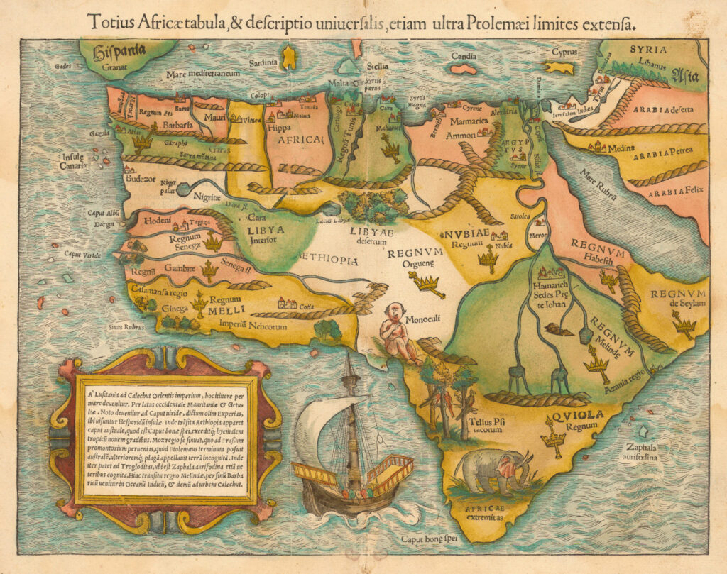
Münster, Sebastian, 1489-1552
Münster’s Africa contained:
- A one-eyed giant representing the mythical “Monoculi” tribe.
- A dense forest stretching across areas now known as the Sahara Desert.
- An enormous elephant dominating southern Africa.
- The legendary Mountains of the Moon feeding the Nile.
- The mythical kingdom of Prester John.
- Ancient Nubian sites associated with Meroë.
The Nile’s source was believed to lie in lakes connected to mysterious lunar mountains. Even more intriguing, Münster depicted a great river loop that closely resembled the actual course of the Niger River centuries before European explorers officially confirmed it in the nineteenth century. Surprisingly, later cartographers abandoned this relatively accurate feature for nearly 200 years.
This map demonstrates that sixteenth-century Europeans possessed fragments of genuine African knowledge mixed with classical traditions, traveler tales, and myths inherited from antiquity.
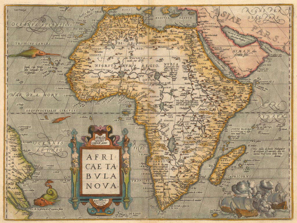
1584: The Birth of the Modern Atlas
Ortelius, Abraham,1527-1598.
Thirty years later, Abraham Ortelius published what became the standard map of Africa during the late sixteenth century. Ortelius is often regarded as the creator of the first true modern atlas.
His map marked an important shift. While uncertainties remained, Africa was increasingly being represented as a geographic space rather than merely a collection of legends. Coastlines became more refined, navigation improved, and information from Portuguese voyages was incorporated.
European maritime powers had established regular contact with African coastal regions, but the continent’s interior remained largely unknown to outsiders. As a result, maps still relied heavily on secondhand reports and inherited assumptions.
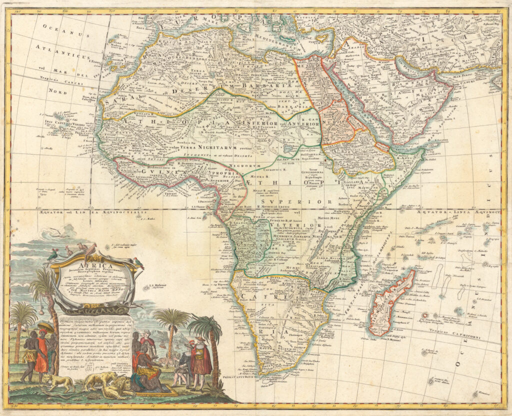
The Seventeenth Century: Africa as a Land of Trade and Wonder
By the mid-1600s, Dutch cartographers had become leaders in mapmaking. Their maps reflected the commercial ambitions of the Dutch Golden Age. The famous Blaeu maps transformed Africa into a visually spectacular continent.
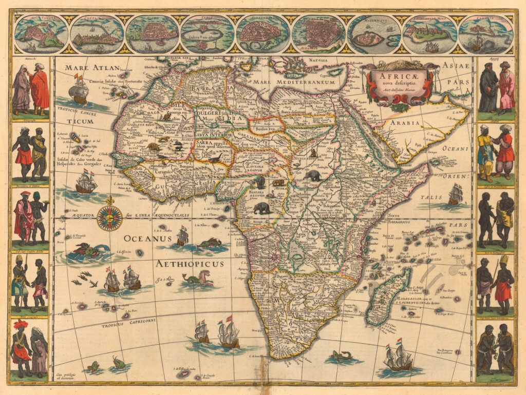
Blaeu, Willem Janszoon, 1571-1638.
These maps featured:
- Detailed illustrations of African cities and trading ports.
- Images of local peoples and clothing.
- Lions, elephants, ostriches, and exotic wildlife.
- Elaborate decorative cartouches and sea creatures.
Beyond their beauty, these maps revealed how Europeans increasingly viewed Africa through the lens of commerce. Trading centers such as Elmina on the Gold Coast gained prominence, reflecting the growing importance of Atlantic trade networks.
The maps also outlined large territories such as Abyssinia and Monomotapa. However, many of these vast political entities reflected European assumptions about nationhood rather than the more complex realities of African political organization. Hundreds of kingdoms, chiefdoms, and ethnic communities existed across the continent, many of which remained unmapped by Europeans.
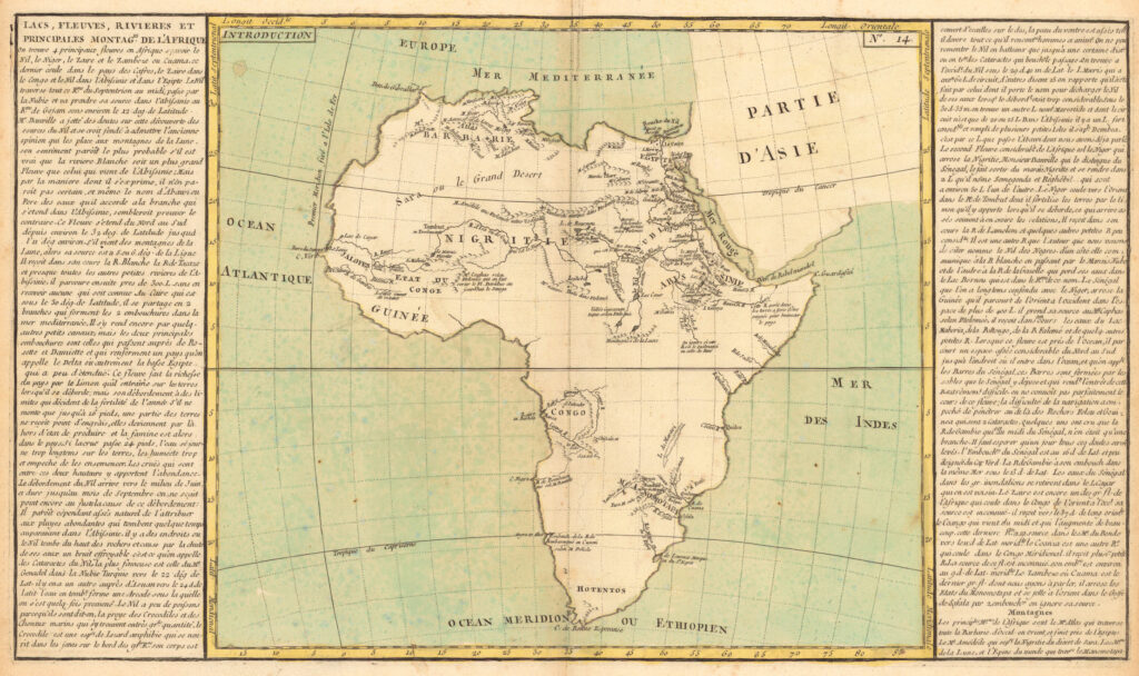
1710–1737: The Age of Scientific Cartography Begins
The eighteenth century brought a stronger emphasis on observation and measurement. Cartographers increasingly attempted to distinguish between verified geography and speculation.
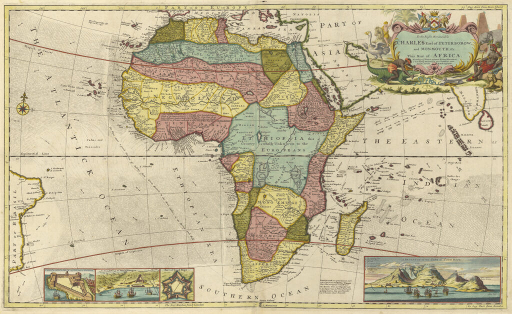
Moll, Herman, d. 1732
German cartographer Johann Matthias Hase’s 1737 map reflected this transition. Large portions of central Africa were openly labeled as unknown territory. Instead of pretending certainty, mapmakers began acknowledging what they did not know.
Hase, Johann Matthias, 1684-1742.
This honesty marked a significant step in cartographic science.
One notable development involved the search for the Nile’s source. Earlier maps had relied on Ptolemy’s ancient theories. Hase replaced some of these older assumptions with newer geographic hypotheses, including a long narrow lake in southeastern Africa roughly corresponding to what would later be identified as Lake Malawi.
The map’s artwork also reflected changing economic interests. Palm oil, ivory, and other commodities featured prominently, revealing Europe’s growing commercial engagement with African markets.
1787: Africa in the Classroom
By the late eighteenth century, maps were increasingly used for education. French scholar Jean-Baptiste Louis Clouet produced a simplified school map designed to teach geographic knowledge rather than impress viewers with decorative imagery.
Clouet, J. B. L. (Jean-Baptiste Louis), b. 1730.
The map highlights an important reality: despite centuries of coastal exploration, much of Africa’s interior remained unknown to Europeans.
Students learned about:
- Major rivers.
- Mountain systems.
- Caravan routes crossing the Sahara.
- The newly understood source of the Blue Nile.
Knowledge was advancing, but large blank spaces still dominated the map.
1805: The Mystery of the Niger River
At the beginning of the nineteenth century, one question obsessed European geographers: Where did the Niger River flow?
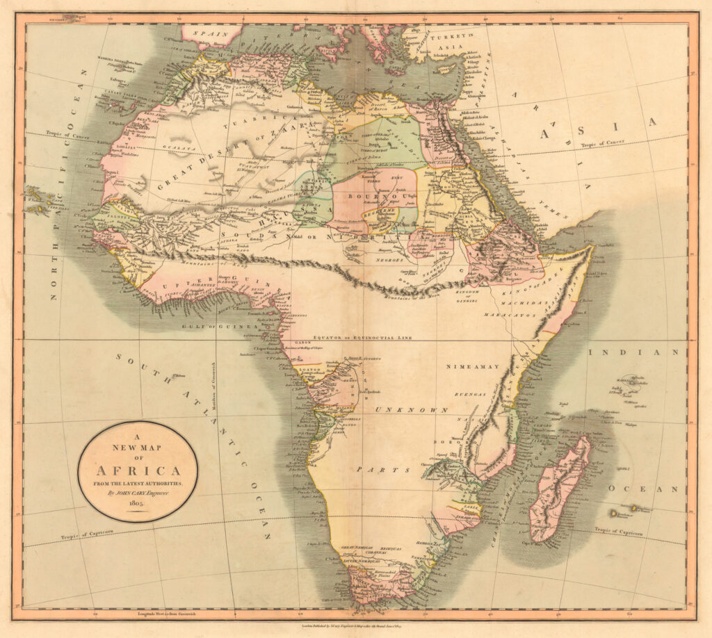
Cary, John, ca. 1754-1835.
The river had been known for centuries, yet its course remained one of geography’s greatest puzzles. Maps published by John Cary reflected ongoing attempts to solve the mystery. At the same time, explorer Mungo Park was undertaking his second expedition to trace the river, a journey that ultimately ended in his death.
The search for the Niger symbolized a broader challenge. Africa’s coastline was becoming increasingly well mapped, but its interior river systems remained among the least understood geographic features on Earth.
1851–1852: Exploration Expands the Map
By the middle of the nineteenth century, decades of exploration had transformed European knowledge of Africa. British explorers had crossed parts of the Sahara, navigated sections of the Niger River, and documented large regions of West and Southern Africa.
Yet significant uncertainty remained.

Tallis, John, 1817-1876.
John Tallis’s celebrated 1851 map acknowledged that more than five-sixths of Africa was still unknown to European geographers. The legendary Mountains of the Moon continued to appear in geographic discussions, and many river systems remained only partially understood.
The map also highlighted Africa’s linguistic diversity, noting the existence of numerous languages across the continent. This reflected growing recognition that Africa was not a single cultural unit but a vast mosaic of societies and civilizations.
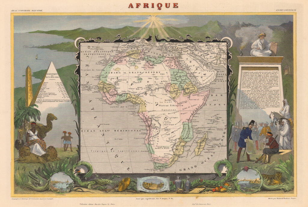
Levasseur, Victor.
French cartographer Victor Levasseur produced a contrasting map in 1852. While less geographically advanced, it surrounded Africa with political and cultural imagery that reflected France’s growing imperial interests.
1856–1880: The Great Age of African Exploration
No period transformed the mapping of Africa more dramatically than the quarter century between 1856 and 1880. Princeton’s collection identifies this era as perhaps the most productive period of African exploration in history.
Several famous explorers contributed to this geographic revolution:
- David Livingstone explored Southern Africa.
- Richard Francis Burton investigated East Africa.
- John Hanning Speke identified major lake systems.
- Henry Morton Stanley mapped vast areas of Central Africa.
The 1880 map by Eugène Andriveau-Goujon reveals how dramatically knowledge had expanded.
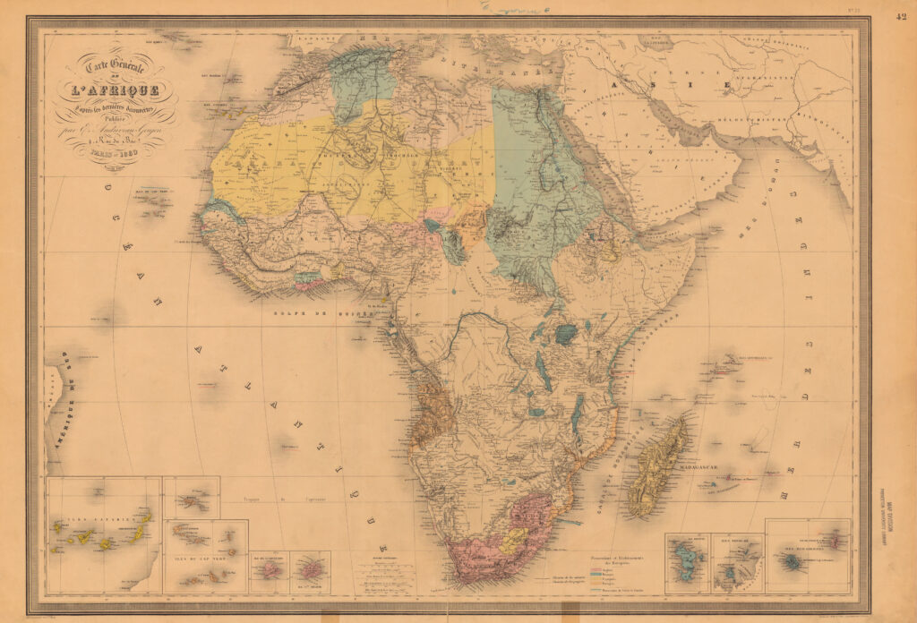
Andriveau-Goujon, E. (Eugène)
Previously mysterious regions now contained:
- Lake Tanganyika.
- Lake Victoria.
- Lake Albert.
- More accurately mapped river systems.
- Better-defined political territories.
The enormous imaginary lake that once occupied central Africa disappeared and was replaced by actual lakes identified through exploration. The mythical “Land of the Moon” gradually gave way to observable geography.
At the same time, another transformation was visible. European-controlled territories began appearing in color-coded sections. The map not only documented geographic discovery but also foreshadowed the coming Scramble for Africa. Within a few years, European powers would partition much of the continent at the Berlin Conference, fundamentally reshaping African history.
From Myth to Measurement
The evolution of African maps between 1554 and 1880 is not merely a story about geography. It is a record of changing human understanding.
The Africa of Münster was a continent of legends, giant creatures, mythical kingdoms, and uncertain rivers. The Africa of Andriveau-Goujon was a continent increasingly defined by measured observations, surveyed lakes, traced rivers, and expanding political ambitions.
Yet these maps reveal something deeper. Every map reflects the priorities, assumptions, and limitations of its age. Early cartographers filled blank spaces with myths. Later cartographers filled them with scientific observations. By 1880, many maps also began filling them with imperial claims.